In surveying, compass instruments are used to determine the orientation of surveying lines using a magnetic compass, while their lengths are typically measured with tapes, chains, or advanced tools like laser range finders. Two popular tools stand out among the commonly used instruments: the prismatic compass and the surveyor compass. This article examines how these tools differ and why surveyors and navigators might choose one.
What Is a Prismatic Compass & Its Components?

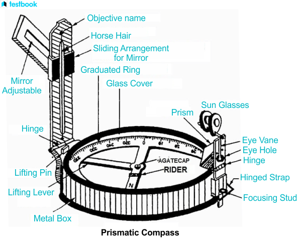
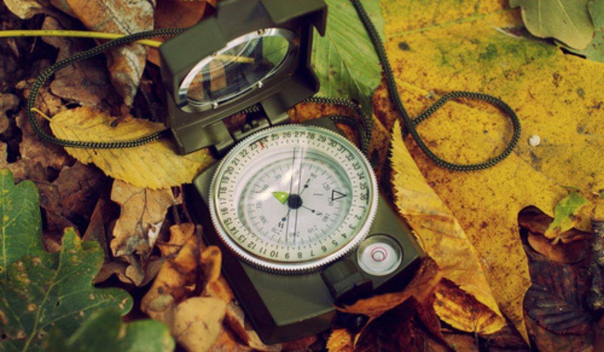
A prismatic compass is a small, easy-to-carry tool that surveyors use to measure magnetic bearings of lines and angles between two points. It uses the earth's magnetic field and finds wide applications in navigation and surveying jobs that need exact angle measurements. Its name comes from the presence of a prismatic lens, which aids in reading the graduated circle while aligning with the sight.
It primarily comprises a magnetic needle, a graduated circle, and a sighting line. When aligned with a specific line, the magnetic needle naturally points toward the magnetic meridian. The angle between the line and the magnetic meridian can then be read from the graduated circle. However, a compass alone cannot directly measure the angle between two separate lines.
Parts of a Prismatic Compass
Magnetic Needle
A needle with magnetic properties that aligns with the Earth's magnetic field. It points to magnetic north and helps measure bearings.
Graduated Circle
A round ring-shaped disc marked in degrees (0°–360°) to determine bearings between a line and the magnetic meridian.
Prism
A small triangular prism positioned near the graduated circle for accurate reading of bearings. Magnifies the readings and ensures clear visibility of measurements.
Compass Box
The cylindrical or rectangular casing that houses the components of the compass, protecting it from damage.
Sight Vane (or Sighting Slit)
A vertical slit with a fine wire or hairline used for sighting the object or landmark being surveyed.
Lifting Pin and Brake
A mechanism to lift and secure the magnetic needle when the compass is not in use. Prevents unnecessary wear and tear of the needle.
Pivot
A small, pointed support on which the magnetic needle is balanced. Allows the needle to rotate freely and align with the magnetic meridian.
Glass Cover
A transparent cover that protects the graduated circle and magnetic needle from external factors like dust and moisture.
Base Plate
The flat base of the compass, often featuring a ruler or scales to assist in map reading.
Cylindrical metal box
The main body of the compass that houses all components. Protects the internal parts from external damage and ensures durability.
Object vane
A vertical vane is used to see the object to be measured. Helps in aligning the compass precisely with the target line.
Eye vane
A viewing device through which the surveyor observes the target and reads the bearing.
Eye slit and eye hole
Openings on the eye vane that ensure proper alignment of the sighting line.
Sunglasses
Small tinted glasses to reduce glare and provide clear visibility during bright conditions.
Spring break
A device used to stop the oscillation of the magnetic needle quickly. Ensures stability when taking readings.
Reflector mirror
Helps observe the needle’s alignment and reading without shifting the instrument.
Focusing stud
Used to adjust the prism for clear and sharp visibility of the graduated circle.
What Is a Surveyor Compass & Its Components?

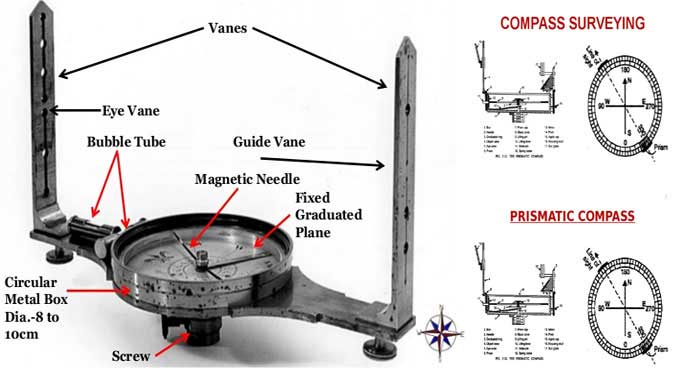
A surveyor compass is a larger, more traditional compass used for measuring horizontal angles and magnetic bearings. It is commonly used in land surveying, where the compass is mounted on a tripod for greater stability and precision. Unlike the prismatic compass, it lacks a prism and focuses more on providing broader directional readings.
Parts of a Surveyor Compass
Compass Box
A circular or rectangular casing that holds the main components, offering protection and durability.
Magnetic Needle
A freely moving needle that points towards the magnetic north, helping in orientation.
Graduated Ring
A ring marked with 360° (or 0°–90° quadrants) for measuring bearings.
Sighting Vanes
Two vertical vanes—one with a slit and the other with a crosshair or wire—for aligning and sighting landmarks or objects.
Pivot
A sharp metal pin on which the magnetic needle rotates smoothly.
Lifting Lever
A mechanism to lift the magnetic needle off the pivot when not in use.
Glass Cover
A sturdy, transparent cover that protects the needle and graduated ring from dust, moisture, and other elements.
Tripod Stand
A three-legged stand used to mount the compass, ensuring stability during measurements.
Circular Level (Bubble)
A small levelling device that ensures the compass is horizontally aligned before taking measurements.
Difference Between Prismatic Compass and Surveyor Compass
Although the prismatic compass and surveyor compass are used for surveying and measuring bearings, they differ significantly in design, functionality, and application. Below is a detailed comparison of the two instruments:
|
Feature |
Prismatic Compass |
Surveyor Compass |
|
Graduation Circle |
Fixed to a broad magnetic needle and does not rotate with the line of sight. |
Fixed to the compass box and rotates along with the line of sight. |
|
Viewing End |
Equipped with a prism for precise observations and reading. |
Has a simple slit at the viewing end with no prism. |
|
Sighting and Reading |
Both sighting and reading can be performed simultaneously. |
Sighting and reading must be done separately, as they cannot be simultaneous. |
|
Magnetic Needle |
Does not act as an index for readings. |
Serves as an index while taking readings. |
|
Graduations |
Uses a whole-circle bearing (WCB) system. |
Uses a quadrantal bearing system, also known as Reduced Bearing (RB). |
|
Markings |
Graduations are inverted as they are read through the prism. |
Graduations are direct and not inverted. |
|
Reading Method |
Readings are observed through the prism for clarity and precision. |
Readings are observed directly from the top glass of the compass. |
|
Tripod Usage |
Can be used with or without a tripod and can even be handheld. |
Requires a tripod for accurate and stable usage. |
Read More: Surveying in Civil Engineering
Uses of Prismatic Compass
1. Determining Bearings
The prismatic compass is widely used to measure the magnetic bearings of survey lines. Bearings indicate the angle between a specific direction (such as north) and a line, which is crucial for mapping and navigation.
2. Mapping and Charting
It is an essential tool for field mapping, especially in terrains where GPS may not be accessible. Surveyors and navigators use it to create detailed maps by measuring angles and directions accurately.
3. Traversing
The compass is instrumental in traversing, a surveying technique for measuring consecutive lines to establish a connected series of points. The prismatic compass provides quick and reliable angular measurements between these lines.
4. Navigation
Adventurers, hikers, and explorers often turn to the prismatic compass when they're out and about in new places. It's useful for figuring out which way to go and marking important spots to remember.
5. Mapping the Waters
When it comes to mapping out lakes and coasts, the compass steps in to measure all the angles and stuff. This ensures the maps of these water areas are as good as possible.
6. Geological Surveys
It assists geologists in mapping out rock formations, fault lines, and other geological features by providing directional data.
Uses of Surveyor Compass
1. Measuring Horizontal Angles
The surveyor compass is specifically designed to measure horizontal angles with high precision, making it ideal for larger surveying projects like land division and boundary marking.
2. Determining Magnetic Bearings
Like the prismatic compass, it is used to measure the magnetic bearings of survey lines, which is essential for plotting and aligning land features on maps.
3. Topographic Surveys
The surveyor compass influences topographic surveys where it assists surveyors to measure angles between natural and human-built features to create accurate terrain models.
4. Construction Planning
In construction projects, it is used to determine and align the layout of structures, roads, and pipelines, ensuring proper orientation and placement.
5. Land Surveys
Land surveyors use it in cadastral surveys to measure land parcels and determine property boundaries.
6. Mining Surveys
It aids in mining surveys to determine the direction and angle of underground tunnels, ensuring accurate mapping of excavation sites.
7. Agricultural Planning
The surveyor compass is used to plan irrigation systems, farm layouts, and land levelling by providing precise directional measurements.
8. Mounted Precision with Tripod
The surveyor's compass, unlike the prismatic compass, often sits on a tripod, which allows for steadier and more precise readings for long surveying jobs.
In Conclusion
The prismatic compass and surveyor compass each have their own special uses that fit different surveying jobs. You can carry the prismatic compass around more and use it for multiple things. The surveyor compass, on the other hand, stands firm and gives more exact results for large-scale projects.
If you're curious about the prismatic and survey compass and want to learn more about it, explore the BIM Professional Course for Civil Engineers offered by Novatr and see how it aligns with your professional aspirations.
For more information on civil engineering and related topics, head to our Resources Page.
Was this content helpful to you


.jpg)


