---
title: Using BIM-GIS Integration for Analysing Civil Engineering projects
description: Learn how BIM-GIS integration helps civil engineers improve planning, analysis, coordination, and decision-making across infrastructure projects.
image: https://blog.novatr.com/hubfs/pasted%20image%200%20(1)-1.png
---
[Blogs](https://www.novatr.com/learning-hub)
- [Architecture & Construction](https://www.novatr.com/learning-hub?category=Architecture+%26+Construction)
- [BIM](https://www.novatr.com/learning-hub?category=BIM)
- [Computational Design](https://www.novatr.com/learning-hub?category=Computational+Design)
- [Company News](https://www.novatr.com/learning-hub?category=Company+News)
- [Expert Talks](https://www.novatr.com/learning-hub?category=Expert+Talks)
Explore Courses
[Just Launched  BIM Professional Program v.2026 Take your career to the next level by mastering the real-world application of BIM. Know More](https://www.novatr.com/courses/bim-professional-program)
[ Master Computational Design Course Break into an advanced career by learning to apply the power of computation to the art of design. Know More](https://www.novatr.com/courses/computational-design)
[Blogs](https://www.novatr.com/learning-hub)
Explore Blogs
- [Architecture & Construction](https://www.novatr.com/learning-hub?category=Architecture+%26+Construction)
- [BIM](https://www.novatr.com/learning-hub?category=BIM)
- [Computational Design](https://www.novatr.com/learning-hub?category=Computational+Design)
- [Company News](https://www.novatr.com/learning-hub?category=Company+News)
- [Expert Talks](https://www.novatr.com/learning-hub?category=Expert+Talks)
Courses
- [BIM Professional Program v.2026](https://www.novatr.com/courses/bim-professional-program)
- [Master Computational Design](https://www.novatr.com/courses/computational-design)
- [CIVIL/](https://www.novatr.com/learning-hub?category=BIM)
Featured Article
# How Can BIM-GIS Integration Help in Civil Engineers Projects?

Pragya Sharma
May 27, 2024
8 min read
-1.png)

BIM-GIS integration is becoming increasingly important in civil engineering as projects grow larger, more complex, and closely tied to their surrounding environments. Civil engineers now need to consider not only the design of structures but also terrain, utilities, transportation networks, and environmental conditions. [BIM](https://www.novatr.com/blog/bim-in-civil-engineering-explained) provides detailed building-level data, while GIS adds geographic and spatial context, helping teams view projects within real-world locations.
By combining these two systems, engineers can reduce planning errors, improve infrastructure analysis, and support better decision-making from early planning to long-term asset management. This article explains **BIM-GIS integration** by covering BIM and GIS basics, the integration process, key benefits, real-world applications, and answers to common questions.
Unlock High-Paying Careers With BIM
Master BIM workflows, software and skills on real projects.
Apply Now
\*Limited seats available
## **What is BIM?**
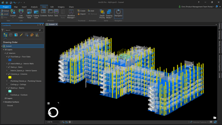
BIM is a process that involves creating and managing digital 3D models representing the physical and functional characteristics of a built structure. It facilitates a centralised database housing comprehensive information about every aspect of a building like its geometry, spatial relationships, geographic information, quantities, and properties of building components. This enables architects, civil engineers, and other construction professionals to collaboratively design and visualise projects in a highly detailed manner. It helps them make informed decisions throughout the entire lifecycle of a building.
## **What is GIS?**
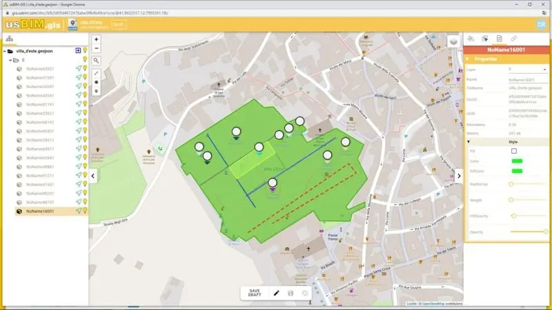
Geographic Information Systems (GIS) is a method for capturing, storing, managing, analysing, and visualising spatial or geographical data. The system allows users to represent real-world objects like roads, rivers, cities, and land parcels as digital maps. These objects are identified as layers, each containing attribute data that provides additional information about these features. By integrating spatial and attribute data, GIS enables users to perform advanced analysis, make informed decisions, and solve complex problems related to location-based information.
*Also Check out: [Exploring the Most Innovative BIM Projects in Europe](https://www.novatr.com/blog/bim-projects-europe)*
## **What is the Need for Integrating BIM and GIS?**
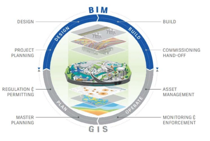
BIM-GIS integration is crucial for understanding site and project details. It helps streamline the design and construction process by aiding data-driven decision-making. Take a look below at the process of BIM and GIS integration and why it is essential for civil engineers:
### **1. Enhanced Spatial Understanding**
A primary driver for integrating BIM and GIS lies in the need for a more comprehensive and accurate understanding of the built spaces. While BIM shares information about the physical and functional attributes of a structure, GIS offers spatial context by capturing geographic data and inter-spatial relationships. By blending these two datasets, civil engineers can gain a project's holistic view that enables them to make better-informed decisions and achieve better spatial planning.
Moreover, with the rise of [spatial computing](https://www.novatr.com/blog/what-is-spatial-computing), engineers can now analyze, simulate, and visualize real-world environments in more immersive ways, further enhancing the effectiveness of BIM-GIS integration.
### **2. Project Lifecycle Management**
For complex construction projects that involve the coordination of multi-disciplinary teams, GIS-integrated BIM works like a charm. It helps streamline workflows and data exchange across all project phases. This ensures that professionals have access to up-to-date, accurate information throughout the project lifecycle, thereby facilitating coordination, collaboration, and communication among project teams.
### **3. Optimised Resource Allocation**
Effective resource allocation helps in maximising the functional efficiency of a structure. By integrating BIM and GIS data, engineers can identify the optimal locations for placing infrastructure, utilities, and facilities within a building or infrastructure facility. This spatial analysis helps streamline and diversify resources, minimise conflicts, and enhance the overall performance of construction projects.
### **4. Sustainable Design**
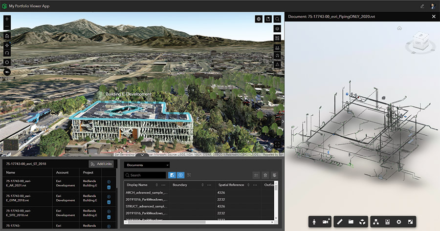
With growing concerns about climate change and global warming, integrating BIM and GIS can prove instrumental in promoting sustainable design and construction practices. Engineers can use the data to analyse environmental factors such as terrain, vegetation, and natural resources to make decisions that minimise environmental impact. Further, integrated BIM-GIS systems facilitate energy analysis, carbon footprint analysis, and life cycle assessments, helping design and operate buildings with greater efficiency.
### **5. Urban Planning and Development**
Combining BIM with GIS can help model and simulate urban environments, assess the impact of proposed developments, and optimise land use planning. This comprehensive approach may enhance the efficiency and effectiveness of urban planning initiatives, fostering sustainable, resilient cities for the future.
## **Process of BIM-GIS Integration**
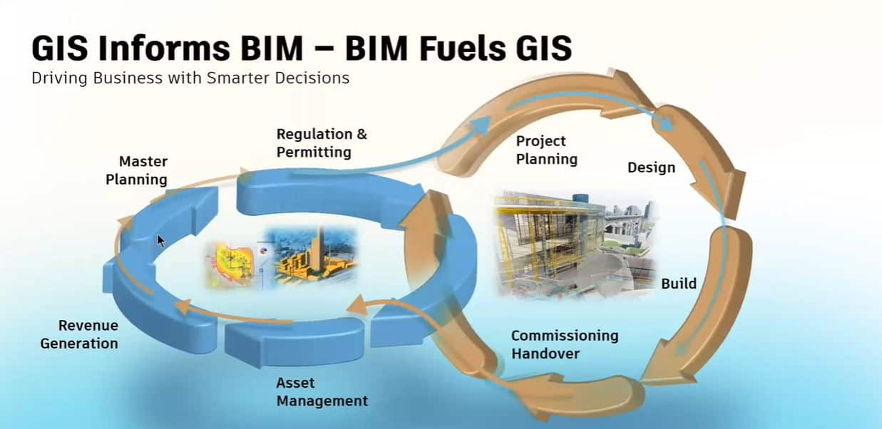
The procedure for integration of GIS with BIM involves the synchronisation of various aspects. Let’s take a look at the step-by-step methodology to understand the nitty-gritty.
### 1. Data Preparation
This includes the integration of spatial and attribute data from BIM models and GIS databases for standardisation. It ensures that datasets are compatible and ready for integration for seamless collaboration and analysis.
### 2. Data Integration
The integration process kicks into high gear as linkages between BIM and GIS datasets are established. Interoperability can be enhanced by enabling GIS attributes within the BIM environment and georeferencing BIM elements to the real-world coordinates.
### 3. Data Analysis
Leveraging the combination of BIM and GIS, design and construction teams can explore spatial relationships, conduct site analysis, and assess the environmental impacts of the project with precision and detail.
### 4. Decision-making
By using integrated BIM-GIS data, stakeholders can evaluate design scenarios, mitigate risks, and optimise resource allocation, driving efficiency and innovation throughout the project lifecycle.
### 5. Data Sharing
With established workflows and protocols, all project stakeholders can share integrated BIM-GIS data, fostering collaboration, communication, and alignment across multiple teams.
*Also Check out: [Exploring the 8 Most Innovative BIM Projects in the Middle East](https://www.novatr.com/blog/bim-projects-middle-east)*
## **How is BIM-GIS Integration Beneficial for Civil Engineers?**
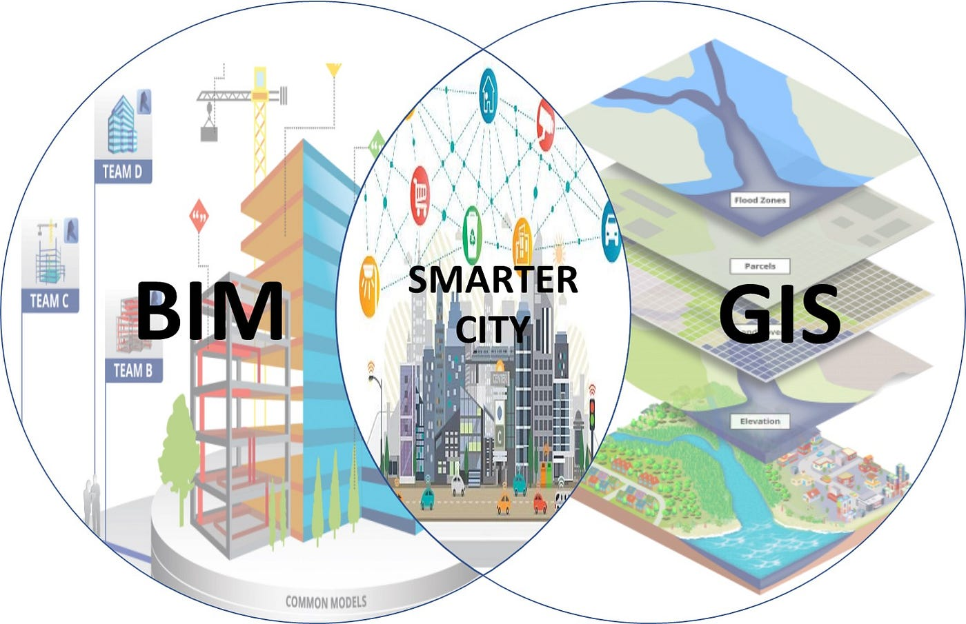
BIM-GIS integration brings the best of both the software to the table. It helps in the development of a tool that is future-forward and more holistic. Mentioned below are the key advantages of how BIM and GIS integration can be useful for civil engineers.
### **1. Improved Project Visualisation**
The integration of BIM with GIS can help civil engineers gain a holistic view of projects by overlaying BIM models onto geographic locations. This allows for better visualisation and understanding of how infrastructure interacts with the surrounding environment. This also enables the creation of 3D models that are in coherence with their neighbourhood.
### **2. Ease of Communication**
BIM-GIS integration facilitates collaboration among multidisciplinary teams involved in a project's planning, design, and construction. Civil engineers can use GIS data, such as topography, land use, and environmental factors to update BIM models in real-time through a shared platform between the project team.
### **3. Accurate Clash Detection**
Clash identification is a critical aspect of construction project management to find and resolve conflicts among building systems and components. Through the adoption of GIS-integrated BIM, civil engineers can conduct clash detection not only within the BIM environment but also against real-world geographic features, thereby mitigating risks and minimising errors and rework during construction.
### **4. Improved Asset Management**
Civil engineers can link BIM models with GIS data to achieve comprehensive asset inventories. These models can include information about each component's location, condition, and maintenance history, thus facilitating more effective asset management strategies.
### **5. Optimised Resource Allocation**
With integrated BIM-GIS workflows, civil engineers can analyse spatial data to optimise resource allocation and scheduling. By considering factors such as transportation routes, proximity to suppliers, and environmental constraints, engineers can make data-driven decisions that minimise costs and maximise efficiency throughout the project lifecycle.
### **6. Enhanced Environmental Analysis**
Sustainability plays a significant role in civil engineering projects considering the immense contribution made by the construction industry towards pollution. BIM-GIS integration enables engineers to conduct detailed environmental analysis by interpreting data about ecosystems, watersheds, and habitats.
## **Applications of BIM-GIS Integration in Civil Engineering**
The adoption of GIS-integrated BIM has become prominent across residential, commercial, and infrastructure projects of varying scales. Let’s delve deeper into the useability of BIM and GIS integration for civil engineering.
### **1. Design Optimisation**
BIM-GIS integration provides civil engineers with an understanding of site elements such as topography, terrain, and environmental factors. They can use this data to optimise the infrastructure planning and design of projects. For instance, identifying optimal routes for roads, railways, pipelines, and utilities can be made more efficient.
### **2. Site Analysis**
GIS data helps assess factors like land use, zoning regulations, soil conditions, and environmental constraints, while BIM models offer detailed information about existing structures and infrastructure. This streamlines the site selection process, ensuring that projects are economically viable and environmentally sustainable from the outset.
### **3. Environmental Impact Assessment**
With the help of GIS data on environmental factors such as vegetation, water bodies, and wildlife habitats, engineers can simulate and analyse the potential environmental impacts of development projects. It can help professionals mitigate risks and design projects that minimise ecological disturbance and preserve natural resources.
*Also Check out: [BIM for Structural Engineers: Top Benefits, Significance, and Work Opportunities](https://www.novatr.com/blog/benefits-of-bim-for-structural-engineers)*
### **4. Urban Infrastructure Management**
In urban environments, BIM-GIS integration facilitates the management of complex infrastructure networks such as water supply, sewage systems, and transportation networks. This enables proactive building maintenance, asset management, and decision-making, ensuring the reliability and resilience of urban infrastructure systems.
### **5. Disaster Management and Resilience**
The fusion of BIM and GIS aids in disaster management and resilience planning usually associated with natural disasters such as floods, earthquakes, and hurricanes. Through the use of GIS data on hazard maps, population density, and critical infrastructure, civil engineers can simulate disaster scenarios, identify vulnerable areas, and develop strategies to enhance resilience and preparedness.
Master BIM and Get Hired Faster
Join a community of 8500+ Architects and Engineers.
Explore Now
\*Limited seats available
## **In Conclusion**
BIM-GIS integration is the “it” thing for civil engineers who want to build structures coherent with their surroundings. Looking ahead, civil engineers can anticipate the development of advanced tools and platforms tailored to their specific needs, facilitating seamless interoperability between BIM and GIS systems.
If you are a civil engineering student or a professional, learning BIM with GIS integration would be your smartest move towards creating a successful career in the industry. To help you achieve that, we recommend you explore the [BIM Professional Course for Civil Engineers](https://www.novatr.com/courses/bim-for-civil-engineers) by [Novatr](https://novatr.com/). It is a one-of-a-kind course especially curated for people from civil engineering backgrounds to gain relevant knowledge about BIM, as applicable in their work field. The program offers insights into 10+ BIM software and their industry workflows through lectures delivered by subject matter experts. The course is backed with real-life case studies, live sessions, and a RIBA-structured capstone project to help participants apply their knowledge to practice. Further, Novatr offers placement support for all the course participants which helps them secure a job in the top-level construction firms internationally.
Explore the [course](https://www.novatr.com/courses/bim-for-civil-engineers)today!
## FAQs
### 1. Why is BIM-GIS integration important for civil engineering projects?
BIM-GIS integration is important because it connects building design data with real-world geographic information. This helps civil engineers improve planning accuracy, understand site conditions better, and make informed infrastructure decisions early in the project.
### 2. How does BIM-GIS integration improve infrastructure planning?
BIM-GIS integration improves infrastructure planning by combining detailed models with spatial data such as terrain, utilities, and land use, allowing engineers to analyze site constraints and optimize layouts more effectively.
### 3. What tools are commonly used for BIM-GIS integration?
Common tools for BIM-GIS integration include Autodesk Revit, Civil 3D, ArcGIS, InfraWorks, and Navisworks. These platforms support data exchange, visualization, and analysis across BIM and GIS environments.
### 4. Can BIM-GIS integration reduce project risks and errors?
Yes, BIM-GIS integration reduces risks by identifying spatial conflicts, improving coordination, and supporting data-driven decisions. Early issue detection helps minimize design errors, rework, and unexpected challenges during construction.
### 5. What challenges are faced while integrating BIM and GIS?
Common challenges include data compatibility issues, large data volumes, and the need for skilled teams. Clear standards, proper data preparation, and suitable tools help address these integration challenges.
Was this content helpful to you
Like Yes
Dislike No
-1.png)
TABLE OF CONTENTS
BIM Is The New Standard. Are You Certified?
Get Certified in BIM
SHARE ON YOUR SOCIALS
Link Copied Successfully
Related articles
[ CIVIL 10 Essential Software For Highway Engineer in 2026 5 August 2025 5 min read](https://blog.novatr.com/blog/10-essential-software-for-highway-engineer) [ CIVIL 10 Best Structural Engineering Firms in Florida: Miami, Tampa & Jacksonville 6 June 2025 10 min read](https://blog.novatr.com/blog/best-structural-engineering-firms-in-florida) [ CIVIL Essential Tips to Make a Stunning BIM Coordinator Resume 26 September 2025 5 min read](https://blog.novatr.com/blog/essential-tips-to-make-a-stunning-bim-coordinator-resume) [ CIVIL 20 Best Civil Engineering Project Topics 27 November 2024 10 min read](https://blog.novatr.com/blog/civil-engineering-project-topics)
Download Syllabus
## BIM Professional Program
Next Cohort
June 2026
Program Duration
7 Months
Premium Program benefits
8 Credentials from Autodesk, NSDC, Novatr
1 program. 10 career paths. Infinite Growth.
40+ ISO 19650 & RIBA real-world projects to practice
1-on-1 guidance. Access 400+ industry experts.
Access the biggest AEC-Tech community on the planet. 8500+ and counting
Curated for you by 100+ global BIM leaders.
Lifelong access to course content
Enter your details to download the program syllabus.
##### BIM Professional Program
June 2026, 7 Months
Your Name Invalid name.
Phone Number Enter a valid phone number
Email Please enter a valid email address.
Select years of experience\* Currently studying 0-1 years 1-2 years 2-4 years 4-8 years 8-10 years 10-12 years 12+ years Invalid selection.
Specialisation Select your background\* Architecture Civil Engineering Mechanical Engineering Electrical Engineering Invalid selection.
Are you professionally trained in interior design?
Yes
No
I agree to the [Terms of Use](https://www.novatr.com/terms-and-conditions) and [Privacy Policy](https://www.novatr.com/privacy-policy), and consent to be contacted by Email, Call, WhatsApp, or SMS.
Submit
Ready to skyrocket your career?
Begin your next chapter in AEC
with Novatr!
We are here to help you take the industry by storm with advanced, tech-first skills.
[Explore Courses](https://www.novatr.com/#courses)
Join our newsletter
Submit
Thank you for signing up.
We’ll send you a nice letter once per week. No spam.

Dare to Disrupt.
Join thousands of people who organise
work and life with Novatr.
Company
- [About Us](https://www.novatr.com/about)
- [BIM Professional Program v.2026](https://www.novatr.com/courses/bim-professional-program)
- [Masters Computational Design](https://www.novatr.com/courses/computational-design)
- [Become a Mentor](https://www.novatr.com/apply-as-mentor)
- [Hiring from Us](https://www.novatr.com/hire-from-us)
- [Careers at Novatr](https://www.novatr.com/career)
Resources
- [Blog](https://www.novatr.com/learning-hub)
- [Media Room](https://www.novatr.com/media-room-home-page)
- [Career Builder](https://www.novatr.com/career-navigator)
- [Events & Webinars](https://www.novatr.com/webinars)
- [FAQs & Support Center](https://www.novatr.com/contact-us)
- [Contact Us](https://www.novatr.com/contact-us)
- [Privacy Policy](https://www.novatr.com/privacy-policy)
- [Terms of Use](https://www.novatr.com/terms-and-conditions)
©2023 Oneistox Network Pvt. Ltd.
All Rights Reserved
```json
{
"@context" : "https://schema.org",
"@type" : "BlogPosting",
"author" : {
"@type" : "Person",
"name" : "Pragya Sharma",
"url" : "https://blog.novatr.com/blog/author/pragya-sharma"
},
"dateModified" : "2026-01-19T11:13:06.952Z",
"datePublished" : "2024-05-27T13:01:00.000Z",
"headline" : "Using BIM-GIS Integration for Analysing Civil Engineering projects",
"image" : [ "https://blog.novatr.com/hubfs/pasted%20image%200%20(1)-1.png" ],
"mainEntityOfPage" : {
"@id" : "https://blog.novatr.com/blog/bim-and-gis-for-civil-engineering",
"@type" : "WebPage"
},
"publisher" : {
"@type" : "Organization",
"logo" : {
"@type" : "ImageObject",
"url" : "https://blog.novatr.com/hubfs/Novatr%20Prev%20OX-2.svg"
}
}
}
```